* adjust buil_cutout.py and Snakefile * try adjusting build_renewable_profiles, currently crashing due to weird pyproj error * build_renewable_profiles: -remove printing gid * build_renewable_profiles: use dask for paralellization, use dense functions * build_renewable_profiles: - revise imports - add logging for long calculation - revise explaining comment - revise distance calculation * build profiles: adjust to cutout.grid * * fix area to square km * rename potmatrix -> capacity_potential * rename available to availibility * config.default update cutout params build_renewable_potentials: major refactoring and simplification hydro_profiles: update code * build profiles: fix weight output dimensions * build profiles: fix typo, fix selection of buses * build profiles: reinsert paths variable * follow up * build profiles: move to dask calculation only * CI: set build cutout to true (add CDSAPI) * build profiles: use pyproj, test with gleas and geokit upstream * environment.yaml fix atlite version * build profiles: use dask 'processes' for more than 25 regions * build profiles: specify dask scheduler according to number of regions * backpedal a bit, only allow scheduler='processes' * follow up, code style and fixup * build profiles: add logger info for underwater fraction calc * config adjust cutout parameters Snakefile fixup * config.default.yaml: adjust resolution * config: use one cutout in total build_cutout: automatic detetection of geographical boundaries * env: add python>=3.8 requirement build_cutout: fixup for region bound * config: allow base cutout * folllow up, fix up * follow up II * clean up * clean up II * build profiles: move back to multiprocessing due to performance issues * small code style corrections * move in pool context * swqitch to ratsterio * switch to rasterio for availibility calculation * tiny fixup * * build continental raster for offshore distance calculation * adjust Snakefile to new script build_raster * rename continental raster to onshore raster add projected_mask function (not yet tested) add docstrings, modularize * Snakefile: remove build_onhore_raster rule, build mask directly from geometry instead build_natura_raster: adjust code, add function for exporting build_profiles: * add buffer to shore distance to init_globals function * update docstrings * improve handling of nodata grid codes * add geometry mask if natura raster not activated (the 255 value is an 'eligible' value for the corine data base, do this for excluding data outside the shape) * build_profiles: adjust docstrings * update environment * build profiles: fixup reproject woth padding * follow up, small fixups * fix resampling method checkpoint: reproduces solar profile in tut data * reintegrate plot map code style * config: rename cutout into "base" * build profiles: adjust to new atlite code * natura raster: small fixup * build natura raster: compress tiff file * config: adjust cutout names * build profiles: cover case if no or partial overlap between natura raster and cutout * config-tutorial: adjust cutout params * buid-profifiles: fixup in gebco filter * follow up * update config files * build profiles: select layoutmatrix != 0 * build profiles: speed up average_distance and underwaterfraction * build profiles: fix typo * update release notes build_cutout: only build needed features * update envs * config: add temperature to sarah features * temporary fix for atlite v0.2.1 and new xarray version release * env: remove xarray specification * * remove rule build_country_flh * build profiles: remove sneaked in line * doc: update configuration.rst (section atlite) and corresponding csv table * release notes: fix quotes * build profiles: use 3035 for area calculation * Update envs/environment.docs.yaml * Update scripts/build_cutout.py * Update doc/release_notes.rst Co-authored-by: euronion <42553970+euronion@users.noreply.github.com> * Update doc/configuration.rst Co-authored-by: euronion <42553970+euronion@users.noreply.github.com> * Update scripts/build_cutout.py Co-authored-by: euronion <42553970+euronion@users.noreply.github.com> * update release notes * release notes: add deprecation of 'keep_all_available_areas' build profiles: remove warning for 'keep_all_available_areas' * build cutout: rearrage code, set buffer correctly * Rename tutorial cutout to remove name clash with real cutout. * Update release_notes.rst: Rename tutorial cutout. * retrieve: update cutouts and downloads (alternative) (#237) * retrieve: update cutouts and downloads * retrieve: remove unnecessary import * use snakemake remote file functionality * Snakefile: update zenodo link * update natura remote link (closes #234) * env: update atlite version to 0.2.2 * env: fix dask version due to memory issues * test: retrieve cutout instead of build * test: use tutorial cutout for CI Co-authored-by: euronion <42553970+euronion@users.noreply.github.com> Co-authored-by: Fabian Neumann <fabian.neumann@outlook.de> |
||
|---|---|---|
| .github | ||
| .reuse | ||
| data | ||
| doc | ||
| envs | ||
| LICENSES | ||
| scripts | ||
| test | ||
| .gitattributes | ||
| .gitignore | ||
| .readthedocs.yml | ||
| .travis.yml | ||
| borg-it | ||
| config.default.yaml | ||
| config.tutorial.yaml | ||
| matplotlibrc | ||
| README.md | ||
| Snakefile | ||


![]()

![]()
PyPSA-Eur: An Open Optimisation Model of the European Transmission System
PyPSA-Eur is an open model dataset of the European power system at the transmission network level that covers the full ENTSO-E area. The model is suitable both for operational studies and generation and transmission expansion planning studies. The continental scope and highly resolved spatial scale enables a proper description of the long-range smoothing effects for renewable power generation and their varying resource availability.
The model is described in the documentation and in the paper PyPSA-Eur: An Open Optimisation Model of the European Transmission System, 2018, arXiv:1806.01613.
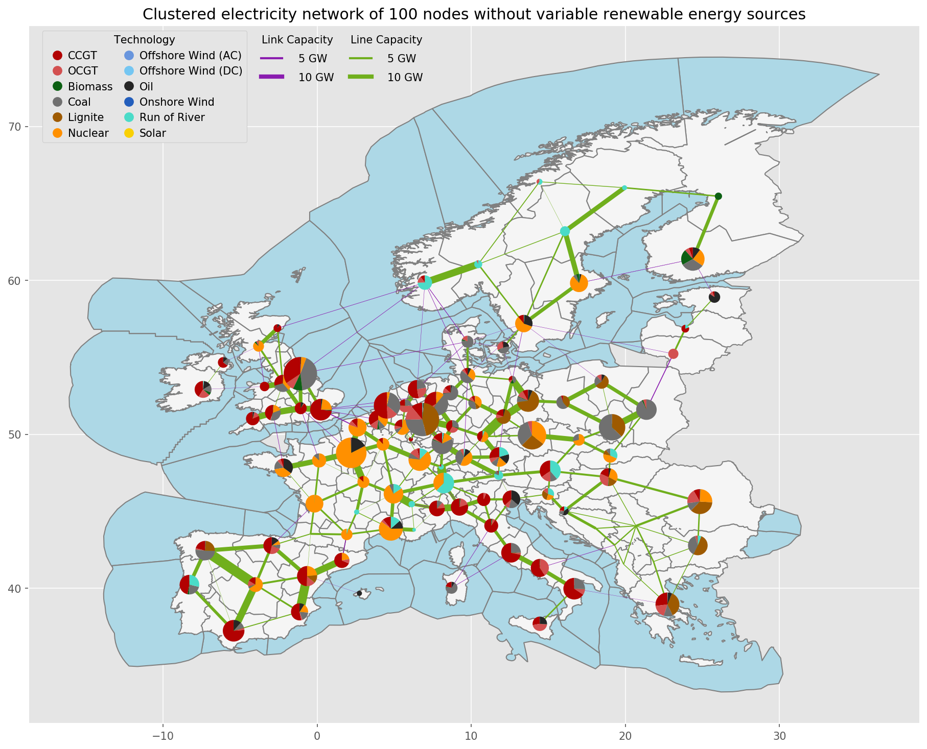
WARNING: Please read the limitations section of the documentation and paper carefully before using the model. We do not recommend to use the full resolution network model for simulations. At high granularity the assignment of loads and generators to the nearest network node may not be a correct assumption, depending on the topology of the underlying distribution grid, and local grid bottlenecks may cause unrealistic load-shedding or generator curtailment. We recommend to cluster the network to a couple of hundred nodes to remove these local inconsistencies. See the discussion in Section 3.4 "Model validation" of the paper.
The model building routines are defined through a snakemake workflow. The model is designed to be imported into the open toolbox PyPSA for operational studies as well as generation and transmission expansion planning studies.
The dataset consists of:
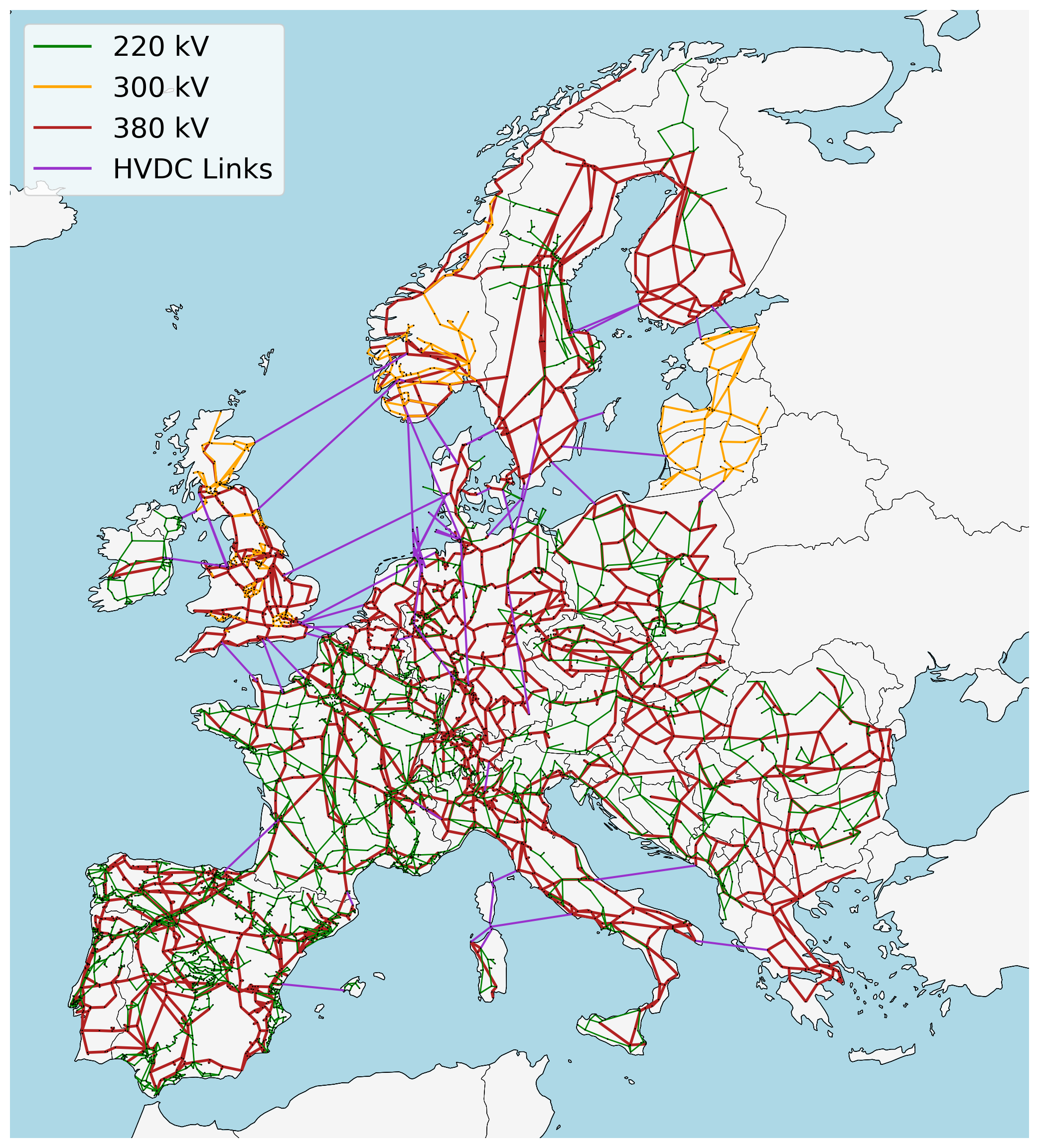
- A grid model based on a modified GridKit extraction of the ENTSO-E Transmission System Map. The grid model contains 6001 lines (alternating current lines at and above 220kV voltage level and all high voltage direct current lines) and 3657 substations.
- The open power plant database powerplantmatching.
- Electrical demand time series from the OPSD project.
- Renewable time series based on ERA5 and SARAH, assembled using the atlite tool.
- Geographical potentials for wind and solar generators based on land use (CORINE) and excluding nature reserves (Natura2000) are computed with the vresutils library and the glaes library.
Already-built versions of the model can be found in the accompanying Zenodo repository.
A version of the model that adds building heating, transport and industry sectors to the model, as well as gas networks, can be found in the PyPSA-Eur-Sec repository.